Industrial manufacturing is the backbone of the global economy, transforming raw materials into a diverse range of essential goods, from the production of automobiles and cutting-edge electronics to the crafting of textiles and furniture. Characterised by its scale and diversity, the industrial manufacturing industry integrates complex processes such as fabrication, assembly, and quality control, ensuring that its outputs meet the highest standards.
There is an ongoing transformation currently well underway. Industry 4.0 marks the integration of automation, data exchange, and advanced manufacturing techniques with traditional industrial practices. It is a new era of smart manufacturing where the Internet of Things (IoT), artificial intelligence (AI), and robotics become integral to production processes, enhancing efficiency, flexibility, and innovation. This integration streamlines operations and opens new avenues for product development, driving the sector towards unprecedented levels of productivity and innovation.
Amidst these technological advancements, several further trends have emerged, shaping the future of industrial manufacturing. Sustainable Manufacturing increases the focus on minimising environmental footprints through the adoption of sustainable materials and energy-efficient practices. These efforts reflect a broader commitment to environmental stewardship, aligning industrial activities with the principles of sustainability. Additionally, Supply Chain Innovation has become a focal point, aiming to build more resilient and efficient logistics networks. These innovations are critical in today’s fast-paced market, enabling manufacturers to respond swiftly to demand fluctuations and supply chain disruptions.
However, the path forward is not without its challenges. Global Competition intensifies as manufacturers worldwide alter their strategies in response to a highly competitive market, pushing companies to continuously innovate and improve efficiency. At the same time, the Workforce Skills Gap poses a significant hurdle, with a pressing need for skilled labour capable of navigating the complexities of advanced manufacturing technologies and processes. Regulatory Compliance further complicates the landscape, as manufacturers must navigate a maze of environmental, safety, and quality standards across different jurisdictions, ensuring their operations adhere to the highest legal and ethical standards.
As the industrial manufacturing sector grapples with these trends and challenges, the integration of space technologies—specifically Earth Observation (EO), Global Navigation Satellite System (GNSS), and satellite communication (SatCom)—offer solutions that advance innovation and improve efficiency. These space-based technologies offer unparalleled opportunities for enhancing operational capabilities, fostering innovation, and overcoming the sector’s most pressing obstacles. The subsequent sections will explore the transformative potential of EO, GNSS, and SatCom, highlighting how their integration into industrial manufacturing not only addresses current challenges but also paves the way for a future where space and industry converge in the pursuit of sustainable, efficient, and innovative manufacturing practices.
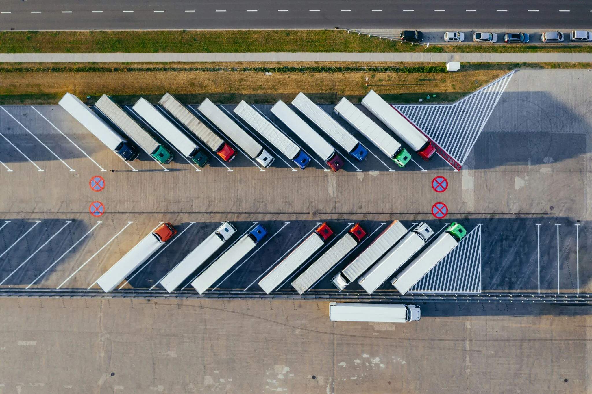
Transport
The efficiency of transport operations plays a huge role in maintaining the rhythm of production and distribution. Through the strategic application of space data the logistics landscape is undergoing a significant transformation. These innovations offer precise tracking and efficient routing, improving the way materials and products move through the supply chain.
Route Optimisation for Material Transport: Leveraging EO data, logistics managers can now monitor real-time weather conditions and natural events, enabling the optimisation of transport routes and schedules. This application not only reduces fuel consumption but also improves delivery times, significantly minimising the risk of delays due to unforeseen obstacles and conditions.
Fleet Management and Tracking: With GNSS, real-time tracking of vehicles and assets throughout the supply chain becomes a reality. From raw material procurement to the delivery of finished products, optimised route planning facilitated by GNSS reduces fuel consumption and delivery times, thereby enhancing overall supply chain efficiency.
Real-time Logistics Tracking: SatCom enables the real-time tracking of materials and products as they journey through the supply chain. Providing updates on location, condition, and estimated arrival times, this level of visibility supports better planning, inventory management, and customer service.
Automated Guided Vehicles (AGVs) Navigation: In the expansive environments of large manufacturing plants, AGVs equipped with GNSS receivers navigate autonomously. These vehicles efficiently and safely transport materials between different sections of the facility, minimising human intervention and the potential for error.
Benefits for Transport
Enhanced Supply Chain Management
Route Optimisation
Real-Time Monitoring
Strategic Planning
Cost Reduction
Environmental Stewardship
The following example solutions – from Smartlane and Carto – show how the integration of space technologies and data with advanced data analytics and AI can transform transport logistics and supply chain management, driving substantial improvements in efficiency, cost savings, and sustainability.
Smartlane
Smartlane offers AI-powered optimisation for transportation management. With features such as automated planning for a configurable fleet, consideration of diverse dispatch and fleet parameters, and seamless TMS integration, Smartlane not only offers time savings for dispatchers but also a significant reduction in fleet operating costs. By improving transparency and resource deployment, Smartlane also enables increased sustainability by lowering overall CO2 emissions. The tangible impacts of these optimisations are profound, with up to a 90% reduction in dispatcher work time, a 20% decrease in fleet operating costs, and €360,000 in annual savings for a medium-sized logistics company.
Carto
Carto offers a solution that leverages spatial analysis to optimise its customers’ supply chains. By leveraging spatial data for route optimisation, Carto achieves a 7% reduction in fleet fuel costs, enhances last-mile logistics to reduce late deliveries by 11%, and improves forecast accuracy by 9% through demand modelling. These solutions address the real-time challenges of delivery and allow for more strategic resource placement and expansion planning.
Integrating these solutions into the industrial manufacturing transport and logistics framework illustrates the substantial benefits of space technologies and data for the industry. Smartlane and Carto, among others such as Geoconcept, are enhancing current operations and redefining the paradigms of efficiency, cost-effectiveness, and environmental stewardship in industrial manufacturing logistics. This convergence of technology and industry enables seamless, sustainable, and efficient transport systems for industrial manufacturing.
Asset Tracking
The ability to track and manage assets throughout the production cycle is essential to the industrial manufacturing sector. The integration of EO, GNSS and SatCom technologies has transformed asset tracking, providing unparalleled visibility and control over assets from raw materials to finished products. This approach streamlines inventory and supply chain management, significantly enhancing efficiency and reducing losses.
Asset Tracking Across Manufacturing Sites: Leveraging EO capabilities, manufacturers can now track the movement and status of assets across vast manufacturing sites. This not only improves inventory management but also optimises operational planning, ensuring that resources are utilised efficiently and production schedules are met.
Inventory Management in Warehousing: The integration of GNSS with RFID and IoT technologies automates inventory tracking within large warehouses or storage areas. This integration ensures accurate stock levels, reduces the frequency of manual inventory checks, and mitigates the risks of overstocking or stockouts.
Remote Asset Monitoring: For assets located in remote or hard-to-reach areas, SatCom enables continuous monitoring of asset performance, facilitates diagnostics, and delivers timely alerts on operational issues, significantly reducing the necessity for on-site visits and associated costs.
Remote Asset Operation: SatCom can be utilised to remotely operate machinery and robotic systems in environments that are hazardous or difficult to access. This extends beyond basic communication, incorporating real-time control of machinery for tasks such as exploration or construction in remote areas, thereby enhancing safety and operational efficiency.
Benefits for Asset Tracking
Asset Visibility
Theft Prevention and Recovery
Inventory Management
Supply Chain Optimisation
The following example solution aims to enhance efficiency and operational transparency within industrial manufacturing. GPX harnesses the power of GNSS and Bluetooth Low Energy (BLE) technologies to offer real-time manufacturing visibility. This is central to the transforming of factories and warehouses into smart, interconnected environments where every asset is accounted for, and operational efficiency is maximised.
GPX
GPX’s technology suite is designed to address the challenges of modern industrial manufacturing. Through inventory tracking and recovery, GPX enables the speedy location of items, drastically reducing search times and minimising losses. Operational insights,including efficiency reports, and asset maps, equip managers with the intelligence to make informed decisions. The early identification of issues is key to prevent costly downtime and operational disruptions. This proactive approach to problem-solving ensures continuous production flow and maintains high operational standards. These solutions result in significant cost reduction, optimising workflows, and managing assets more efficiently. This leads to lower operating expenses, providing a competitive advantage to companies. For a company with $5,000,000 in asset value tracked across 5,000 assets and an annual asset loss rate of 37.5%, with 1,000 hours devoted to recovery operations, the deployment of GPX can result in total savings of $6,927,134,257. This includes $6,927,111,422 in loss savings and $22,835 in operations savings, representing an ROI of 5620.4x. The environmental benefits are notable too, with CO2 reductions equivalent to removing 20 passenger cars from the road annually.
The integration of GPX’s solution within industrial manufacturing creates a smarter, more efficient, and transparent operation. By streamlining asset management, enhancing supply chain visibility, and ensuring proactive operational management, GPX sets a new standard for asset tracking, driving industrial manufacturing towards a more innovative and sustainable future.

Infrastructure
In the industrial manufacturing sector, effective infrastructure management is crucial. EO data provides a high-resolution view of the physical and environmental context of factories and other facilities. Combined with GNSS and SatCom, this data offers the sector increased efficiency and risk mitigation.
Site Selection for New Facilities: The selection of locations for new manufacturing plants is enhanced by satellite imagery and data analytics. This approach allows for the consideration of factors such as proximity to raw materials, access to logistics networks, and susceptibility to natural disasters, thereby optimising operational efficiency and minimising risk exposure.
Maintenance and Safety of Infrastructure: The application of EO data enables a predictive maintenance strategy. By continuously monitoring the structural integrity of facilities, potential issues can be detected before they escalate into costly failures, ensuring a safer working environment and minimising operational disruptions.
Structural Monitoring: The deployment of GNSS for real-time structural monitoring allows for the detection of minute movements or shifts within the infrastructure, allowing for early intervention and maintenance to prevent critical issues.
Land Management and Construction: GNSS technology plays a crucial role in the surveying and land management processes for new manufacturing sites. It ensures that site planning, construction, and subsequent expansions are conducted with precision, adhering to regulatory boundaries and optimising spatial utilisation.
Global Facility Management: SatCom bridges the distances between globally-dispersed manufacturing facilities. It facilitates real-time monitoring, control, and coordination of operations, standardising production quality and efficiency across all locations.
Smart Energy Management: Leveraging satellite data for environmental monitoring allows manufacturers to optimise the use of renewable energy sources. This not only reduces energy costs but also diminishes the carbon footprint of manufacturing operations, aligning with global sustainability goals.
Benefits for Infrastructure
Detect Anomalies
Resolution & Tasking
Enhance Maintenance
Resource Optimisation
Sustainability Practices
Strategic Development
The integration of space technologies is clearly crucial for enhancing operational efficiency and strategic infrastructure management. Example solutions below from SkyFi, Augmenterra and Asterra exemplify this integration, offering innovative services that leverage high-resolution satellite data to provide actionable insights and detailed geographic information.
SkyFi
SkyFi allows industrial manufacturers to monitor and optimise their operations by providing access to high-resolution, recent satellite images. This near-real-time observation capability supports industries, from monitoring transport logistics and managing assets to observing emissions for regulatory compliance and managing infrastructure with the most current geographic information available. SkyFi’s service stands out by offering datasets that can be annotated and customised to fit specific operational requirements, thereby enhancing various facets of the manufacturing process. With detailed elevation data, manufacturers can undertake infrastructure development, maintenance, and logistical planning with unprecedented precision. Advanced hyperspectral analysis allows for the precise identification of materials, proving invaluable for quality control and resource management. This comprehensive visibility leads to a deeper understanding of physical assets and operational dynamics, fostering improved efficiency and the potential for cost reductions across the manufacturing sector.
Augmenterra
Augmenterra specialises in the use of interferometric synthetic aperture radar (InSAR) technology to monitor ground and structural integrity by detecting millimetric shifts that could compromise the safety and durability of manufacturing facilities. Through ground movement analysis, Augmenterra’s InSAR satellite data can identify structural damage, directing repairs and mitigating damages. Its continuous infrastructure monitoring capabilities support proactive maintenance planning, preventing costly repairs and ensuring the continuity of operations in informed decision-making. This helps to avoid unscheduled downtime while extending the lifespan of vital infrastructure, and enables safe, efficient, and cost-effective operations.
Asterra
Asterra harnesses EO data to deliver actionable insights below the Earth’s surface, driving significant cost reductions and enhancing infrastructure resilience for the industrial manufacturing sector. Utilising artificial intelligence and patented algorithms, Asterra’s solutions are designed to detect leaks, assess pipe conditions, and locate moisture near large installations without the need for invasive excavation. Asterra enhances the resilience of infrastructure by facilitating the early detection of potential failures, supporting sustainable development goals and ensuring resilient infrastructure. By identifying leaks in potable water systems water loss can be reduced significantly. Asterra’s EarthWorks solution provides insights into soil moisture and infrastructure integrity, identifying potential risks and enabling preventative maintenance.
These solutions highlight how space technologies can lead to improved operational efficiency, reduced environmental impact, and significant cost savings for industrial manufacturers. SkyFi, Augmenterra and Asterra, along with other companies such as Dares Technology and Sixense, highlight the transformative impact of space technologies on the infrastructure and operational dynamics of the industrial manufacturing sector.

Emissions
In efforts to align industrial manufacturing operations with sustainability goals, the tracking and management of emissions is extremely important. Leveraging EO data, GNSS, and SatCom technologies, manufacturers have the capability to monitor their environmental impact in real-time. This approach provides accurate insights, enabling the implementation of effective strategies to reduce emissions and minimise environmental footprints.
Pollution Monitoring and Reduction: Through the use of satellite data, manufacturing facilities can track their emissions and ensure environmental compliance. By pinpointing pollution hotspots, targeted measures can be implemented to significantly reduce environmental footprints, aligning operations with global sustainability goals and regulations.
Environmental Monitoring and Compliance: The application of GNSS-tagged drones or vehicles extends the scope of environmental monitoring around manufacturing sites. This method ensures adherence to environmental standards by tracking pollution levels, waste management practices, and land use changes, thus maintaining a harmonious balance with the ecosystem.
Global Environmental Monitoring: SatCom technology enhances the capability to monitor environmental conditions globally, including air and water quality around manufacturing sites. This global perspective is instrumental in helping companies comply with stringent environmental regulations and in fostering the adoption of more sustainable manufacturing practices.
Benefits for Emissions Monitoring
Enhanced Emissions Monitoring
Regulatory Compliance
Emissions Management
Operational Efficiency
Informed Decision Making
Risk Management
Example solution, Floodlight, leverages space technologies to offer precise emissions tracking and analysis, enabling companies to enhance their Environmental, Social, and Governance (ESG) efforts and carbon footprint management.
Floodlight
Floodlight is a specialised platform offering comprehensive ESG and carbon data analysis. It enables industrial manufacturers to achieve asset-level measurement of ESG factors and greenhouse gas emissions, providing the granular data necessary for informed decision-making. This platform supports regular reporting on emissions across various gas types and aids manufacturers in understanding their environmental impact more clearly. Integration with existing business standards like the SASB and GHG Protocol ensures that reporting is both reliable and regulatory compliant. Furthermore, the comprehensive data provided guides companies toward achieving their net-zero commitments and tracking their emissions impact over time. Floodlight enhances emissions monitoring and reduction by offering functionalities that include asset-level greenhouse gas emissions monitoring, regulatory compliance and reporting, benchmarking and performance tracking, and supply chain assessment.
Floodlight underscores the importance of accurate emissions data in steering the industrial manufacturing sector towards more sustainable practices. By providing actionable insights into emissions sources and impacts, these solutions not only aid in regulatory compliance but also drive operational efficiencies, reduce costs, and bolster the industry’s commitment to environmental stewardship.
Digital Twins
Digital twins are transforming industrial manufacturing by offering digital models that accurately represent real-world entities or systems. These encompass everything from individual products and processes to entire facilities and infrastructures. With the ability to dynamically update and change in real-time, digital twins mirror the physical world, enhancing analysis, simulation, and control. This advancement is driving better decision-making, fostering innovation, and increasing operational efficiency. Digital twins are a central enabler of innovation in industrial manufacturing. They offer a toolkit for improving efficiency, driving sustainability, and fostering innovation, transforming how the industry approaches and manages operations.
Supply Chain Optimisation: Digital twins are streamlining supply chains by simulating and optimising logistics routes, predicting potential delays, and identifying risk mitigation strategies, making supply chains more efficient and resilient.
Innovation in Design: Fed with accurate, up-to-date data, digital twins facilitate extensive testing and simulation scenarios. This capability is crucial for driving innovative product designs and improving performance, pushing the boundaries of what’s possible in manufacturing.
Operational Efficiency: The integration of space data into digital twins provides valuable insights into external factors affecting production. This includes environmental conditions or supply chain disruptions, enabling manufacturers to adapt and optimise manufacturing processes swiftly.
Sustainability and Environmental Compliance: Leveraging EO data, digital twins aid in the monitoring and management of emissions, resource usage, and overall environmental impact. This not only supports compliance with stringent regulations but also aligns operations with sustainability goals.
Safety and Risk Management: Through the simulation of various safety scenarios, digital twins enhance planning for workplace safety and emergency responses, improving preparedness and mitigating potential risks effectively.
Market Responsiveness: In reacting to market changes and consumer demand patterns, digital twins allow manufacturers to swiftly adjust production processes. This agility is crucial for maintaining a competitive edge in rapidly evolving markets.
Development of Digital Twins
Data Collection
Model Creation
Integration
Simulation
Optimisation
The integration of space data into digital twins underscores the essential role of EO, GNSS, and SatCom in enhancing the accuracy, responsiveness, and operational capabilities of these digital models. These technologies are key to taking full advantage of the advancements that Industry 4.0 is enabling.
Earth Observation
EO data provides critical environmental data that directly impacts physical entities, from infrastructure facilities to the natural environment surrounding manufacturing sites. This invaluable data streamlines the creation of digital twins that are not only accurate but highly responsive to real-world changes. Whether it’s for infrastructure planning, maintenance, or environmental monitoring, EO data enriches digital twins by offering visual confirmation of their status, ensuring models are synchronised with their physical counterparts with unmatched precision.
Global Navigation Satellite Systems
In the industrial manufacturing supply chain assets are constantly move across geographical areas. GNSS is central to providing precise positioning and timing information, enabling the accurate monitoring and tracking of mobile assets, from parts, to vehicles, to shipping containers. This precision is instrumental in developing digital twins for these assets, facilitating their efficient management and synchronisation over large distances, optimising logistics and supply chain operations.
Satellite Communications
SatCom, for digital twins, offers the global and reliable connectivity that is so essential for continuous data transmission between the digital twin and its physical counterpart. This is particularly crucial in remote or challenging environments where traditional communication networks might be unavailable or unreliable. This connectivity ensures that digital twins can be controlled and synchronised effectively, regardless of the physical location of the asset, enabling seamless operations and data flow.
The centrality of space technologies in enabling and enhancing digital twins within industrial manufacturing cannot be overstated. Through the integration of EO, GNSS, and SatCom, digital twins achieve a level of accuracy and operational efficiency that is otherwise unattainable. This integration not only optimises the management of assets and infrastructure but also ensures digital twins are responsive to changes, true to their physical counterparts and capable of supporting remote operations. By harnessing space technologies, industrial manufacturing can leverage digital twins to drive innovation, enhance operational efficiency, and advance toward sustainability goals and environmental compliance. Solutions for developing digital twins are increasingly available and can offer significantly customised services to fit the specific digital twinning needs of a company, as the example below illustrates.
Twyn
Twyn specialises in digital twin development, aiming to enhance operational efficiency, streamline manufacturing processes, and significantly reduce maintenance costs, all while improving equipment effectiveness. The platform offers a comprehensive suite of features designed to optimise every facet of the manufacturing process. By enhancing operational planning and resource allocation with precise, real-time data, Twyn enables manufacturers to achieve new levels of efficiency and precision. This enables continuous monitoring and virtual replication of manufacturing processes. This real-time oversight ensures that any deviations or inefficiencies are quickly identified and addressed, maintaining the integrity and continuity of operations. Their solution provides plug-and-play libraries that seamlessly integrate with industry systems. This inclusivity extends across mechanical, electronic, and software domains, enabling a comprehensive digital representation that spans the entire manufacturing ecosystem. Leveraging edge computing, the platform conducts real-time health monitoring of assets. This proactive approach to maintenance anticipates issues before they escalate into costly downtime, thereby enhancing equipment effectiveness and operational resilience. This means that a predictive maintenance approach can be implemented to foresee potential faults and optimise maintenance schedules accordingly. This enhances operational workflow and cost savings by preventing unnecessary repairs and downtime.