Definition
What is Earth observation?
Earth observation (EO) is the gathering of information about the Earth's surface, waters and atmosphere by sensors on satellites, aircraft or the ground, and its processing into maps and measurements. Optical sensors record reflected light; radar sensors send microwave pulses and work through cloud and at night. Copernicus data and services are free of charge.
- Technologies
- Updated
- Published by
- LETO SPACE
Earth observation is behind many satellite-based services for cities and companies, from heat maps to the monitoring of construction sites. This page explains how it works, which types of data exist, what is free and what its limits are.
Definition
- Earth observation (EO)
Earth observation is the gathering of information about the Earth's surface, waters and atmosphere through satellite, airborne or ground-based remote sensing, and the processing and analysis of that information to monitor the state of the natural and built environment and how it changes.
- Also called: EO; in German: Erdbeobachtung
01Technology
How Earth observation works
A satellite carries one or more sensors. Passive sensors record natural energy that is reflected or emitted by the Earth's surface; active sensors send their own signal and record what comes back Source: U.S. National Oceanic and Atmospheric Administration (NOAA), National Ocean Service, 23 September 2026U.S. National Oceanic and Atmospheric Administration (NOAA), National Ocean ServiceWhat is remote sensing?23 September 2026Open source (opens oceanservice.noaa.gov). Optical instruments are passive: they record reflected energy in visible light and in infrared bands. Radar instruments are active: they send microwave pulses to the Earth and record how these pulses are reflected Source: European Space Agency (ESA), accessed 6 October 2026European Space Agency (ESA)What is Earth observation?accessed 6 October 2026Open source (opens esa.int).
Satellite images are usually shown as pictures, but they are digital data, and the same raw data can be processed in many different ways Source: European Space Agency (ESA), accessed 6 October 2026European Space Agency (ESA)What is Earth observation?accessed 6 October 2026Open source (opens esa.int). Providers deliver them at defined processing levels. For Sentinel-2, for example, Level-1C products are top-of-atmosphere reflectance, resampled to a ground sampling distance of 10, 20 or 60 m depending on the band, and Level-2A products are surface reflectance, corrected for the effects of the atmosphere Source: Copernicus Data Space Ecosystem, accessed 6 October 2026Copernicus Data Space EcosystemSentinel-2 (product documentation)accessed 6 October 2026Open source (opens documentation.dataspace.copernicus.eu).
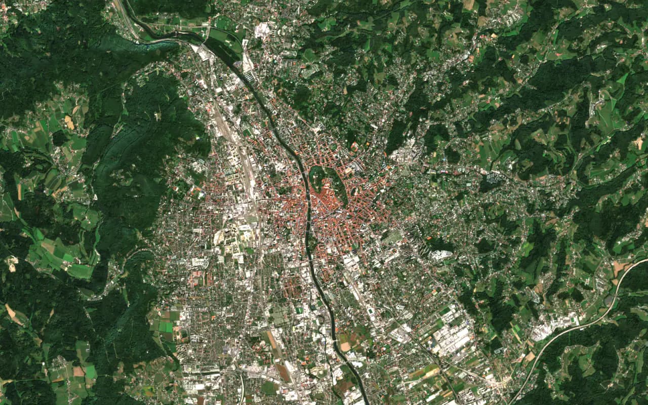
The Committee on Earth Observation Satellites (CEOS) defines Analysis Ready Data as satellite data that have been processed to a minimum set of requirements and organised so that they can be analysed immediately, with little additional effort, and combined over time and with other datasets Source: Committee on Earth Observation Satellites (CEOS), accessed 6 October 2026Committee on Earth Observation Satellites (CEOS)CEOS Analysis Ready Dataaccessed 6 October 2026Open source (opens ceos.org). Analysis ready does not mean ready for your decision: whether a product fits a task still has to be checked against the requirements of that task.
02Data
Optical, radar, thermal and hyperspectral data
Each type of sensor shows a different aspect of the surface. The choice follows the question you need to answer.
| How it works | Example mission | Typical uses | |
|---|---|---|---|
| Optical (multispectral) | Records reflected sunlight in several wavelength bands | Sentinel-2: 13 bands, 10 m at best, 290 km swath | Agriculture, forests, land cover and its change, coastal and inland waters |
| Radar (SAR) | Sends microwave pulses and records the echo, through cloud and at night | Sentinel-1 | Flooded areas, ground motion, ships at sea |
| Thermal infrared | Records heat emitted by the surface | Landsat 9: two thermal bands, 100 m | Surface temperature, urban heat |
| Hyperspectral | Records the spectrum in many narrow, adjacent bands | EnMAP: 420 to 2450 nm, sampled every 6.5 to 10 nm, 30 m | Telling materials apart in more detail |
Mission figures and uses: Sentinel-2 Source: European Space Agency (ESA), accessed 6 October 2026European Space Agency (ESA)Sentinel-2: Facts and figuresaccessed 6 October 2026Open source (opens esa.int), Sentinel-1 Source: European Space Agency (ESA), accessed 6 October 2026European Space Agency (ESA)Sentinel-1accessed 6 October 2026Open source (opens esa.int) Source: European Space Agency (ESA), 3 November 2025European Space Agency (ESA)Sentinel-1 mission… did you know?3 November 2025Open source (opens esa.int), Landsat 9 Source: U.S. Geological Survey (USGS), accessed 6 October 2026U.S. Geological Survey (USGS)Landsat 9accessed 6 October 2026Open source (opens usgs.gov), EnMAP Source: German Aerospace Center (DLR), EnMAP, accessed 6 October 2026German Aerospace Center (DLR), EnMAPEnMAP missionaccessed 6 October 2026Open source (opens enmap.org) Source: German Aerospace Center (DLR), EnMAP, accessed 6 October 2026German Aerospace Center (DLR), EnMAPEnMAP HSI instrument specificationaccessed 6 October 2026Open source (opens enmap.org).
Radar mainly measures surface roughness rather than light or heat Source: European Space Agency (ESA), accessed 6 October 2026European Space Agency (ESA)What is Earth observation?accessed 6 October 2026Open source (opens esa.int). Repeated radar images also show how buildings, bridges and the ground move over time, with millimetre precision at continental scale in the European Ground Motion Service Source: European Space Agency (ESA), 3 November 2025European Space Agency (ESA)Sentinel-1 mission… did you know?3 November 2025Open source (opens esa.int). This technique, InSAR, has its own page: InSAR ground motion monitoring.
03Resolution
Resolution and revisit
"High resolution" is not one number. Four kinds of resolution describe what a sensor can deliver:
- Spatial resolution: the minimum size of detail visible in an image Source: European Space Agency (ESA), accessed 6 October 2026European Space Agency (ESA)What is Earth observation?accessed 6 October 2026Open source (opens esa.int).
- Spectral resolution: the number and width of the wavelength bands an optical instrument records. More bands allow materials to be told apart more accurately Source: European Space Agency (ESA), accessed 6 October 2026European Space Agency (ESA)What is Earth observation?accessed 6 October 2026Open source (opens esa.int).
- Temporal resolution: how often the satellite images the same place, also called revisit.
- Radiometric resolution: how finely the sensor distinguishes differences in the recorded energy. The imager on Landsat 9, for example, distinguishes 16,384 levels per band Source: U.S. Geological Survey (USGS), accessed 6 October 2026U.S. Geological Survey (USGS)Landsat 9accessed 6 October 2026Open source (opens usgs.gov).
These properties pull against each other. The higher the spatial resolution of an instrument, the narrower its swath, the strip of ground covered in one pass, and this generally means a longer revisit time Source: European Space Agency (ESA), accessed 6 October 2026European Space Agency (ESA)What is Earth observation?accessed 6 October 2026Open source (opens esa.int). Sentinel-2 images a 290 km swath at up to 10 m and revisits a location at the equator every five days with two satellites Source: European Space Agency (ESA), accessed 6 October 2026European Space Agency (ESA)Sentinel-2: Facts and figuresaccessed 6 October 2026Open source (opens esa.int). Pléiades Neo, a commercial constellation, delivers 30 cm panchromatic images with a swath of 14 km and can revisit a site twice a day, because its satellites can be pointed at a target Source: European Space Agency (ESA), Earth Online, accessed 6 October 2026European Space Agency (ESA), Earth OnlinePléiades Neoaccessed 6 October 2026Open source (opens earth.esa.int). Steerable sensors like these shorten the revisit time Source: European Space Agency (ESA), accessed 6 October 2026European Space Agency (ESA)What is Earth observation?accessed 6 October 2026Open source (opens esa.int). A requirement should therefore name the resolution it means and the value the task needs.
04Terms
Earth observation and remote sensing
Remote sensing is the science of obtaining information about objects or areas from a distance, typically from aircraft or satellites Source: U.S. National Oceanic and Atmospheric Administration (NOAA), National Ocean Service, 23 September 2026U.S. National Oceanic and Atmospheric Administration (NOAA), National Ocean ServiceWhat is remote sensing?23 September 2026Open source (opens oceanservice.noaa.gov). The term describes the method. Earth observation is the wider activity: it gathers information about the Earth by remote sensing from satellites, aircraft or the ground, and analyses it to monitor the environment and its changes Source: EU Agency for the Space Programme (EUSPA), 13 July 2026EU Agency for the Space Programme (EUSPA)What is Earth Observation?13 July 2026Open source (opens euspa.europa.eu).
In practice, aircraft and drones complement satellites. In selected activations, for example, the Copernicus emergency mapping service complements satellite images with imagery from aircraft and drones; aircraft can often deliver information even in cloudy weather Source: Copernicus EMS, Copernicus Emergency Management Service, accessed 6 October 2026Copernicus Emergency Management ServiceUsing Earth Observation Dataaccessed 6 October 2026Open source (opens mapping.emergency.copernicus.eu). In German, Fernerkundung is the usual word for remote sensing and Erdbeobachtung for Earth observation.
05Programmes
Copernicus, free data and commercial imagery
Copernicus is the Earth observation component of the European Union's Space Programme. It delivers its information through six services, for the atmosphere, the marine environment, land, climate change, security and emergencies Source: European Commission, DG Defence Industry and Space (EU Space portal), accessed 7 October 2026European Commission, DG Defence Industry and Space (EU Space portal)Copernicusaccessed 7 October 2026Open source (opens eu-space.europa.eu). The legal basis is the EU Space Programme Regulation, which provides Copernicus data and information under a free, full and open data policy, with limitations such as predefined formats and security restrictions Source: European Union, EUR-Lex, 12 May 2021European Union, EUR-LexRegulation (EU) 2021/696 of 28 April 2021 establishing the Union Space Programme and the European Union Agency for the Space Programme12 May 2021Open source (opens eur-lex.europa.eu). Sentinel data are available through the Copernicus Data Space Ecosystem, which provides free access; users can register for further functions Source: Copernicus Data Space Ecosystem, accessed 6 October 2026Copernicus Data Space EcosystemCopernicus Data Space Ecosystemaccessed 6 October 2026Open source (opens dataspace.copernicus.eu). Landsat products from the US Geological Survey have been available at no cost since 2008 Source: U.S. Geological Survey (USGS), accessed 6 October 2026U.S. Geological Survey (USGS)Landsat Data Accessaccessed 6 October 2026Open source (opens usgs.gov).
Very high-resolution images are available from commercial missions such as Pléiades Neo, which Airbus Defence and Space owns and operates Source: European Space Agency (ESA), Earth Online, accessed 6 October 2026European Space Agency (ESA), Earth OnlinePléiades Neoaccessed 6 October 2026Open source (opens earth.esa.int). Such data are offered either from an archive of past acquisitions or as new images that a satellite is tasked to acquire. SPOT 6 and 7 data, for example, are available both ways; since SPOT-7 ended in March 2023, new acquisitions come from SPOT-6 only Source: European Space Agency (ESA), Earth Online, accessed 6 October 2026European Space Agency (ESA), Earth OnlineSPOT-6 to 7 full archive and taskingaccessed 6 October 2026Open source (opens earth.esa.int). Prices and conditions of use depend on the provider, so we do not quote them here.
Free data is not a free service: processing, delivery and integration still need effort and budget. The procurement guide explains what to buy around the data.
06Use cases
What Earth observation is used for
Most of the use cases in our library rely on Earth observation. A selection, from cities to agriculture:
- UC-01
Mapping urban heat islands with satellite data
How thermal satellite data shows where a city overheats, which data and satellites it uses, what a heat map delivers and where its limits are.
- UC-02
Flood risk mapping and early warning with satellite data
How satellites support flood risk mapping, flood forecasts and the mapping of flooded areas, which Copernicus services a city can use and where the limits are.
- UC-05
Land use change detection with satellite data
How satellite data tracks land take, sealing and urban expansion, which Copernicus layers a region can use, and where their limits are.
- UC-07
Disaster management with satellite data and communication
How satellite images map floods and damage within hours or days, how authorities request Copernicus rapid mapping, and how satcom helps when networks fail.
- UC-14
InSAR ground motion monitoring with satellite radar
What InSAR is, how radar satellites measure millimetre ground motion under infrastructure, and what the free European Ground Motion Service offers.
- UC-15
Construction progress monitoring with satellite imagery
How satellite imagery tracks progress on large and multi-site construction projects: change detection, resolution, radar, outputs and limits.
- UC-18
Climate risk assessment for properties with satellite data
How satellite data, hazard maps and climate projections rate the exposure of buildings to flooding, wildfire and ground movement, and where the limits are.
- UC-23
CSRD reporting with satellite data
Which parts of CSRD reporting can be enriched automatically, what satellite data adds on land, vegetation and emissions at your sites, and what it cannot do.
- UC-27
Forest monitoring with satellite data
How satellite data detects forest damage, bark beetle stress and deforestation: Copernicus forest layers, Sentinel-1 and Sentinel-2 time series, and limits.
07Limits
Limits
Limit 01
Optical sensors need clear skies
Optical instruments record reflected light, so clouds hide the ground. Radar sees through cloud and darkness, but it shows surface roughness, not colour Source: European Space Agency (ESA), accessed 6 October 2026European Space Agency (ESA)What is Earth observation?accessed 6 October 2026Open source (opens esa.int).
Limit 02
Detail costs coverage
The finer the detail, the smaller the area per pass and, as a rule, the longer the revisit Source: European Space Agency (ESA), accessed 6 October 2026European Space Agency (ESA)What is Earth observation?accessed 6 October 2026Open source (opens esa.int). Objects smaller than a pixel cannot be seen reliably.
Limit 03
The right image may not exist
In emergency mapping, the first available image is often of limited quality: partly cloudy, taken at an oblique angle far from the vertical or covering only part of the area. An image from before the event is not always available Source: Copernicus EMS, Copernicus Emergency Management Service, accessed 6 October 2026Copernicus Emergency Management ServiceUsing Earth Observation Dataaccessed 6 October 2026Open source (opens mapping.emergency.copernicus.eu).
Limit 04
A map is not ground truth
A classified map is the result of a model. Before it informs a decision, it needs validation against reference data from the area, with a stated method and accuracy.
08Key terms
Key terms
- Swath: the width of the area a sensor covers in one pass.
- Revisit time: the time between two images of the same place.
- Ground sampling distance: the distance on the ground between the centres of two neighbouring pixels.
- SAR: synthetic aperture radar, the imaging radar used on Earth observation satellites.
- InSAR: interferometric SAR, which compares the phase of radar images taken at different times to measure ground motion.
- Processing level: the stage of processing a product has reached, for example Level-1C or Level-2A for Sentinel-2.
- Analysis Ready Data: data processed to a minimum standard so that they can be analysed directly, as defined by CEOS.
- In-situ data: observations from ground-based, airborne or seaborne sensors rather than satellites. Copernicus uses them alongside satellite data, among other things to calibrate and validate its products Source: European Union, Copernicus In Situ Component (European Environment Agency), accessed 7 October 2026European Union, Copernicus In Situ Component (European Environment Agency)What is in situ data?accessed 7 October 2026Open source (opens insitu.copernicus.eu).
09Next steps
How we help
We help organisations decide whether Earth observation fits a task, which data and level of processing it needs, and how to procure a service around it. If you are new to the field, start with the definition of space-enabled solutions, which places Earth observation next to satellite navigation, satellite communication and AI.
Frequently asked questions
Q1Is satellite data free?
Much of it is. Copernicus data and information are provided under a free, full and open data policy, with defined limitations Source: European Union, EUR-Lex, 12 May 2021European Union, EUR-LexRegulation (EU) 2021/696 of 28 April 2021 establishing the Union Space Programme and the European Union Agency for the Space Programme12 May 2021Open source (opens eur-lex.europa.eu), and the Copernicus Data Space Ecosystem gives free access to data from the Sentinel missions Source: Copernicus Data Space Ecosystem, accessed 6 October 2026Copernicus Data Space EcosystemCopernicus Data Space Ecosystemaccessed 6 October 2026Open source (opens dataspace.copernicus.eu). Landsat products have been available from the US Geological Survey at no cost since 2008 Source: U.S. Geological Survey (USGS), accessed 6 October 2026U.S. Geological Survey (USGS)Landsat Data Accessaccessed 6 October 2026Open source (opens usgs.gov). Data from commercial very high-resolution missions are not openly available. ESA, for example, offers the full Pléiades Neo archive and new acquisitions for scientific research and application development only on an accepted project proposal and within a quota Source: European Space Agency (ESA), Earth Online, accessed 6 October 2026European Space Agency (ESA), Earth OnlinePléiades Neoaccessed 6 October 2026Open source (opens earth.esa.int).
Q2Can satellites see through clouds?
Radar satellites can. They send microwave pulses and record the echo, so they see through cloud and darkness. Optical satellites record reflected light and cannot see the ground under cloud Source: European Space Agency (ESA), accessed 6 October 2026European Space Agency (ESA)What is Earth observation?accessed 6 October 2026Open source (opens esa.int).
Q3How often is an area imaged?
It depends on the mission. With two satellites, Sentinel-2 revisits a location at the equator every five days Source: European Space Agency (ESA), accessed 6 October 2026European Space Agency (ESA)Sentinel-2: Facts and figuresaccessed 6 October 2026Open source (opens esa.int). Landsat 9 has a 16-day repeat cycle, offset by eight days from Landsat 8 Source: U.S. Geological Survey (USGS), accessed 6 October 2026U.S. Geological Survey (USGS)Landsat 9accessed 6 October 2026Open source (opens usgs.gov). Some commercial constellations, such as Pléiades Neo, can revisit a site twice a day Source: European Space Agency (ESA), Earth Online, accessed 6 October 2026European Space Agency (ESA), Earth OnlinePléiades Neoaccessed 6 October 2026Open source (opens earth.esa.int). For optical data, clouds reduce the number of usable images.
Q4What is the difference between Earth observation and remote sensing?
Remote sensing is the method: obtaining information about objects or areas from a distance, typically from aircraft or satellites Source: U.S. National Oceanic and Atmospheric Administration (NOAA), National Ocean Service, 23 September 2026U.S. National Oceanic and Atmospheric Administration (NOAA), National Ocean ServiceWhat is remote sensing?23 September 2026Open source (opens oceanservice.noaa.gov). Earth observation is the wider activity of gathering information about the Earth's surface, waters and atmosphere by remote sensing from satellites, aircraft or the ground, and analysing it to monitor the environment and its changes Source: EU Agency for the Space Programme (EUSPA), 13 July 2026EU Agency for the Space Programme (EUSPA)What is Earth Observation?13 July 2026Open source (opens euspa.europa.eu).
Sources (20)
- What is Earth Observation? (opens euspa.europa.eu)
- What is Earth observation? (opens esa.int)
- What is remote sensing? (opens oceanservice.noaa.gov)
- Sentinel-2 (product documentation) (opens documentation.dataspace.copernicus.eu)
- CEOS Analysis Ready Data (opens ceos.org)
- Sentinel-2: Facts and figures (opens esa.int)
- Sentinel-1 (opens esa.int)
- Sentinel-1 mission… did you know? (opens esa.int)
- Landsat 9 (opens usgs.gov)
- EnMAP mission (opens enmap.org)
- EnMAP HSI instrument specification (opens enmap.org)
- Pléiades Neo (opens earth.esa.int)
- Copernicus (opens eu-space.europa.eu)
- Regulation (EU) 2021/696 of 28 April 2021 establishing the Union Space Programme and the European Union Agency for the Space Programme (opens eur-lex.europa.eu)
- What is in situ data? (opens insitu.copernicus.eu)
- Copernicus Data Space Ecosystem (opens dataspace.copernicus.eu)
- Landsat Data Access (opens usgs.gov)
- SPOT-6 to 7 full archive and tasking (opens earth.esa.int)
- Using Earth Observation Data (opens mapping.emergency.copernicus.eu)
- Copernicus Sentinel-2 Level-2A scene S2B_33TWN_20250901_0_L2A, true colour image, 1 September 2025 (opens earth-search.aws.element84.com)
Contact
Not sure which satellite data your task needs? Describe the task, and we name the options.
Prefer to talk?
Tell one of our experts about your project. Together we work out where you stand, whether satellite data and AI can help and what a sensible next step would be.
Both calls are free of charge and take place online. You choose a date in our booking calendar.