Use case: construction and real estate
Monitoring ground motion with InSAR
InSAR compares radar images of the same area, acquired from the same viewing geometry at different times. The phase change of the echo shows how far the ground or a structure has moved towards or away from the satellite. Using many images, the European Ground Motion Service specifies a mean velocity resolution better than 1 mm per year.
- Reference
- UC-14
- Technologies
- Challenge
- Asset and infrastructure monitoring
- Updated
- Published by
- LETO SPACE
01Technology
What InSAR is
InSAR stands for interferometric synthetic aperture radar. A radar is an active system: it sends pulses of microwave energy and records the echo, so it provides its own illumination and works without sunlight. Unlike an optical sensor, a radar can see through clouds, fog and dust Source: Copernicus Land Monitoring Service, European Environment Agency (EEA), 7 August 2025Copernicus Land Monitoring Service, European Environment Agency (EEA)European Ground Motion Service (EGMS): Algorithm Theoretical Basis Document, version 47 August 2025Open source (opens library.land.copernicus.eu). Copernicus Sentinel-1 is such a radar satellite and gathers data day and night Source: European Space Agency (ESA), 3 November 2025European Space Agency (ESA)Sentinel-1 mission… did you know?3 November 2025Open source (opens esa.int).
A synthetic aperture radar records both the amplitude and the phase of the echo. The phase carries information about changes in the distance between the sensor and the target Source: Copernicus Land Monitoring Service, European Environment Agency (EEA), 7 August 2025Copernicus Land Monitoring Service, European Environment Agency (EEA)European Ground Motion Service (EGMS): Algorithm Theoretical Basis Document, version 47 August 2025Open source (opens library.land.copernicus.eu). Interferometry compares the phase of two images of the same area, acquired from the same geometry, to make these changes visible. Sentinel-1 works at a wavelength of about 5.55 cm Source: Copernicus Land Monitoring Service, European Environment Agency (EEA), 7 August 2025Copernicus Land Monitoring Service, European Environment Agency (EEA)European Ground Motion Service (EGMS): Algorithm Theoretical Basis Document, version 47 August 2025Open source (opens library.land.copernicus.eu).
Modern processing combines many images instead of two. These multi-interferogram techniques overcome limits of the basic method such as atmospheric noise Source: Copernicus Land Monitoring Service, European Environment Agency (EEA), 7 August 2025Copernicus Land Monitoring Service, European Environment Agency (EEA)European Ground Motion Service (EGMS): Algorithm Theoretical Basis Document, version 47 August 2025Open source (opens library.land.copernicus.eu). Persistent scatterer interferometry, one of these techniques, relies on measurement points whose radar echo stays stable over time Source: Copernicus Land Monitoring Service, European Environment Agency (EEA), 7 August 2025Copernicus Land Monitoring Service, European Environment Agency (EEA)European Ground Motion Service (EGMS): Algorithm Theoretical Basis Document, version 47 August 2025Open source (opens library.land.copernicus.eu). With such techniques, Sentinel-1 tracks how surface features such as houses, bridges and rocky outcrops move vertically and sideways over time Source: European Space Agency (ESA), 3 November 2025European Space Agency (ESA)Sentinel-1 mission… did you know?3 November 2025Open source (opens esa.int).
02Data
The European Ground Motion Service
The European Ground Motion Service (EGMS) is part of the Copernicus Land Monitoring Service. It uses Sentinel-1 radar data to measure ground motion across Europe, and the data are free for anyone to use Source: European Space Agency (ESA), 26 July 2022European Space Agency (ESA)Tap into Europe in motion (European Ground Motion Service)26 July 2022Open source (opens esa.int). It is updated once a year Source: Copernicus Land Monitoring Service, accessed 6 October 2026Copernicus Land Monitoring ServiceEuropean Ground Motion Service (product page)accessed 6 October 2026Open source (opens land.copernicus.eu).
EGMS comes in three product levels Source: Copernicus Land Monitoring Service, European Environment Agency (EEA), 7 August 2025Copernicus Land Monitoring Service, European Environment Agency (EEA)European Ground Motion Service (EGMS): Product Description and Format Specification, version 3.07 August 2025Open source (opens library.land.copernicus.eu):
- Basic: displacement along the satellite's line of sight, relative to a reference point within each processed area.
- Calibrated: the same data referenced to a model derived from GNSS measurements, so that values are absolute and comparable across areas. This is the main product for most users.
- Ortho: vertical and east-west movement, derived from the calibrated product and resampled to a 100 m grid.
- Satellite
- Copernicus Sentinel-1 (radar)
- Mean velocity resolution
- better than 1 mm per year
- Point resolution
- 5 by 20 m for persistent scatterers
- Ortho grid
- 100 m
- Release window
- five years; latest release (April 2026) covers 2020 to 2024
- Cost
- free of charge
Specifications from the EGMS product description, version 3.0, August 2025 Source: Copernicus Land Monitoring Service, European Environment Agency (EEA), 7 August 2025Copernicus Land Monitoring Service, European Environment Agency (EEA)European Ground Motion Service (EGMS): Product Description and Format Specification, version 3.07 August 2025Open source (opens library.land.copernicus.eu), and ESA Source: European Space Agency (ESA), 26 July 2022European Space Agency (ESA)Tap into Europe in motion (European Ground Motion Service)26 July 2022Open source (opens esa.int).
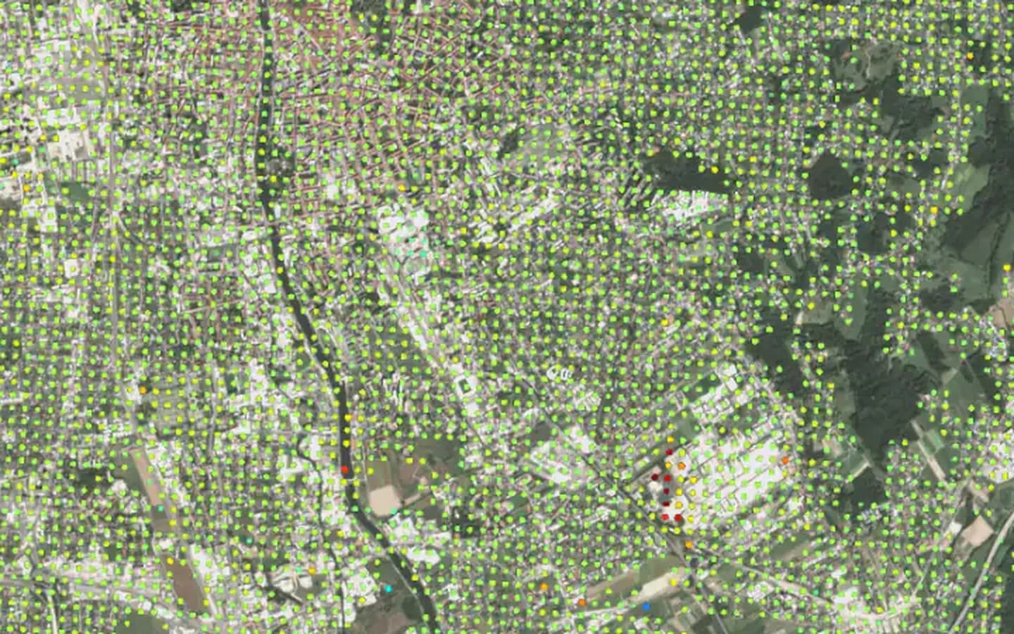
Mean vertical velocity
−10 mm/yr0+10 mm/yr
Moving downMoving up
03When you need it
Where it helps
Radar interferometry is increasingly used to assess ground deformation risk for large infrastructure, the European Ground Motion Service provides millimetre-accuracy maps at European scale, and satellite imagery supports every stage of the infrastructure life cycle, from site selection to post-construction monitoring Source: EU Agency for the Space Programme (EUSPA), 26 May 2026EU Agency for the Space Programme (EUSPA)EU Space Market Report 2026, Issue 126 May 2026Open source (opens euspa.europa.eu):
- Planning: ground deformation risk maps help characterise potential sites.
- Construction: large-scale monitoring of the surroundings detects deformation caused by the works, for example by tunnelling.
- Operation: the wide coverage suits linear infrastructure such as railways, roads, electric lines and pipelines, whose size makes monitoring on site costly.
EGMS maps subsidence and landslides; even modest subsidence can weaken buildings, bridges, railway lines, sewer pipes, dams and sea defences Source: European Space Agency (ESA), 26 July 2022European Space Agency (ESA)Tap into Europe in motion (European Ground Motion Service)26 July 2022Open source (opens esa.int).
04Deliverables
What you get
For each measurement point, the EGMS calibrated product provides the mean velocity, the acceleration, the amplitude of seasonal movement and the full displacement time series Source: Copernicus Land Monitoring Service, European Environment Agency (EEA), 7 August 2025Copernicus Land Monitoring Service, European Environment Agency (EEA)European Ground Motion Service (EGMS): Product Description and Format Specification, version 3.07 August 2025Open source (opens library.land.copernicus.eu). In practice this becomes:
- a map of measurement points coloured by velocity in millimetres per year
- time series for single buildings, bridge sections or route segments
- a list of zones where movement exceeds a threshold that you define
- a basis for targeting on-site equipment at the zones at risk Source: EU Agency for the Space Programme (EUSPA), 26 May 2026EU Agency for the Space Programme (EUSPA)EU Space Market Report 2026, Issue 126 May 2026Open source (opens euspa.europa.eu)
05Limits
Limits
Limit 01
Only along the line of sight
The radar measures movement along its line of sight. It is less sensitive to movement in the north-south direction, which EGMS does not measure with InSAR Source: Copernicus Land Monitoring Service, European Environment Agency (EEA), 7 August 2025Copernicus Land Monitoring Service, European Environment Agency (EEA)European Ground Motion Service (EGMS): Product Description and Format Specification, version 3.07 August 2025Open source (opens library.land.copernicus.eu).
Limit 02
Vegetation and change
Changing vegetation, ploughed fields and demolition or construction disturb the signal Source: Copernicus Land Monitoring Service, European Environment Agency (EEA), 7 August 2025Copernicus Land Monitoring Service, European Environment Agency (EEA)European Ground Motion Service (EGMS): Algorithm Theoretical Basis Document, version 47 August 2025Open source (opens library.land.copernicus.eu). The specified minimum point density is 5,000 per km² in continuous urban areas and 100 per km² in open land with little vegetation Source: Copernicus Land Monitoring Service, European Environment Agency (EEA), 7 August 2025Copernicus Land Monitoring Service, European Environment Agency (EEA)European Ground Motion Service (EGMS): Product Description and Format Specification, version 3.07 August 2025Open source (opens library.land.copernicus.eu).
Limit 03
Steep terrain
In areas of high relief, radar geometry effects (layover, foreshortening and shadow) leave gaps, and the ortho product has no values there Source: Copernicus Land Monitoring Service, European Environment Agency (EEA), 7 August 2025Copernicus Land Monitoring Service, European Environment Agency (EEA)European Ground Motion Service (EGMS): Product Description and Format Specification, version 3.07 August 2025Open source (opens library.land.copernicus.eu).
Limit 04
Not real time
EGMS is updated once a year Source: Copernicus Land Monitoring Service, accessed 6 October 2026Copernicus Land Monitoring ServiceEuropean Ground Motion Service (product page)accessed 6 October 2026Open source (opens land.copernicus.eu). Where a risk develops quickly, ground instruments are needed for real-time monitoring. In mining, satellite data complement in-situ sensors such as ground-based radar and piezometers in monitoring the stability of open pits and tailings dams Source: EU Agency for the Space Programme (EUSPA), 26 May 2026EU Agency for the Space Programme (EUSPA)EU Space Market Report 2026, Issue 126 May 2026Open source (opens euspa.europa.eu).
06Next steps
How we help
Because EGMS data are free, they are a good first step: they show whether ground motion matters for your sites or routes before you specify anything. If you need more, for example recent data during construction works or monitoring linked to your asset management, we write the requirements and compare the providers.
More on strategy and use cases
The marketplace on Spacegraph, our discovery platform, has a use-case category for infrastructure integrity.
07Use cases
Related use cases
- Monitoring pipelines and grid corridorsGround motion, vegetation and activity along energy routes.
- Monitoring rail infrastructureTrack condition and trackside vegetation from satellite data.
- Construction and real estateAll use cases for construction, infrastructure and real estate.
- Mobility and logisticsUse cases for road, rail, aviation and maritime transport.
Frequently asked questions
Q1What is InSAR?
InSAR stands for interferometric synthetic aperture radar. A radar satellite sends microwave pulses and records the strength and the phase of the echo. Interferometry compares the phase of two images of the same area taken from the same geometry, which reveals changes in the distance between the satellite and the ground Source: Copernicus Land Monitoring Service, European Environment Agency (EEA), 7 August 2025Copernicus Land Monitoring Service, European Environment Agency (EEA)European Ground Motion Service (EGMS): Algorithm Theoretical Basis Document, version 47 August 2025Open source (opens library.land.copernicus.eu). Combining many images over time turns these changes into a history of movement for each measurement point.
Q2How accurate is InSAR?
For the European Ground Motion Service, the specified mean velocity resolution is better than 1 mm per year. The standard deviation of a single displacement value is 4 mm in the basic product and 8 mm in the calibrated and ortho products Source: Copernicus Land Monitoring Service, European Environment Agency (EEA), 7 August 2025Copernicus Land Monitoring Service, European Environment Agency (EEA)European Ground Motion Service (EGMS): Product Description and Format Specification, version 3.07 August 2025Open source (opens library.land.copernicus.eu). The mean velocity has a specified standard deviation of 0.7 mm per year; in the basic and calibrated products this applies to points with a coherence above 0.7, which means a stable radar echo Source: Copernicus Land Monitoring Service, European Environment Agency (EEA), 7 August 2025Copernicus Land Monitoring Service, European Environment Agency (EEA)European Ground Motion Service (EGMS): Product Description and Format Specification, version 3.07 August 2025Open source (opens library.land.copernicus.eu).
Q3Is the EGMS data free, and how current is it?
Yes, the data are free and accessible to anyone Source: European Space Agency (ESA), 26 July 2022European Space Agency (ESA)Tap into Europe in motion (European Ground Motion Service)26 July 2022Open source (opens esa.int). The service is updated once a year, and the EGMS Explorer shows the latest two releases Source: Copernicus Land Monitoring Service, accessed 6 October 2026Copernicus Land Monitoring ServiceEuropean Ground Motion Service (product page)accessed 6 October 2026Open source (opens land.copernicus.eu). Each release covers a five-year window Source: Copernicus Land Monitoring Service, European Environment Agency (EEA), 7 August 2025Copernicus Land Monitoring Service, European Environment Agency (EEA)European Ground Motion Service (EGMS): Product Description and Format Specification, version 3.07 August 2025Open source (opens library.land.copernicus.eu); the latest, published in April 2026, covers 2020 to 2024 Source: Copernicus Land Monitoring Service, 29 April 2026Copernicus Land Monitoring ServiceProduct update: European Ground Motion Service 202429 April 2026Open source (opens land.copernicus.eu). If you need data on current works, that becomes a requirement for a dedicated service.
Q4How do we start a pilot?
Look at the free EGMS data for your sites or routes first. They can show whether ground motion is an issue and where. Then decide whether you need more: newer data, a denser network of points or a combination with sensors on site. Our consulting overview shows the path from the problem to operation.
Sources (8)
- European Ground Motion Service (EGMS): Algorithm Theoretical Basis Document, version 4 (opens library.land.copernicus.eu)
- European Ground Motion Service (EGMS): Product Description and Format Specification, version 3.0 (opens library.land.copernicus.eu)
- Product update: European Ground Motion Service 2024 (opens land.copernicus.eu)
- European Ground Motion Service (product page) (opens land.copernicus.eu)
- Tap into Europe in motion (European Ground Motion Service) (opens esa.int)
- Sentinel-1 mission… did you know? (opens esa.int)
- EU Space Market Report 2026, Issue 1 (opens euspa.europa.eu)
- EGMS Explorer: Ortho vertical product (EGMS-ORTHO-U-2024-patch1), release 2020 to 2024 (opens egms.land.copernicus.eu)
Contact
Need to watch sites or routes for ground motion? Talk to us before you commission a dedicated service.
Prefer to talk?
Tell one of our experts about your project. Together we work out where you stand, whether satellite data and AI can help and what a sensible next step would be.
Both calls are free of charge and take place online. You choose a date in our booking calendar.